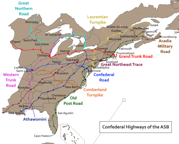
Confederal Highways
The important thing about this map is that "Confederal highways" are rare in the ASB. Most roads are built and regulated by the states, or in some cases by regional committees of a few neighboring states. The confederal highways came into existence as special projects, either because they were too long for regional committees to handle, or becuase they were built between rivals that could not agree, and thus deferred to the Confederation.
That means that a number of major roads and cities are not confederal highways. Some of the oldest and most important of these state and regional roads are shown in grey on the map.
The nine confederal highways are:
That means that a number of major roads and cities are not confederal highways. Some of the oldest and most important of these state and regional roads are shown in grey on the map.
The nine confederal highways are:
- The Great Northern Road: This connects a number of important early fur and settlement trails. At its western end, the GNR originally linked the Red River settlements with the upper Mississippi. At the eastern end it was the main land route that French traders took into the rich Manitoulin and Algoma Countries around Lakes Huron and Superior. In between is a more modern route linking the far northwest with the heart of the Great Lakes. The GNR is especially celebrated in Assiniboia, where it is credited with tying the state to the rest of the ASB and removing it from the orbit of the Hudson's Bay Company.
- The Grand Trunk Road: One of the most-traveled highways in the confederation, the GTR connects New England with the Hudson valley and Iroquoia, and continues into the Great Lakes and the far northwest. Almost the entire length of the road was important in colonial times and today continues to link some of the country's key population centers. The endpoints of the road are the river crossing and old fur post of Pierre in the west, and Provincetown on the extreme tip of Cape Cod in the east.
- The Confederal Road: As the name implies, this was the ASB's first transport project. Its main purpose in the early 19th century was to connect the central part of the Ohio Country with the Chesapeake to the east and the Mississippi valley to the west. It traverses the confederation's narrow waist and represented the growing connections between east and west of that era.
- The Great Northeast Trace: Originally it took shape as a trade route from Louisiana into Choctaw and Chicasaw country. Later it extended northward into the Ohio, reaching as far as the Forks and becoming a major artery for the whole area west of the mountains. From the Forks (now the city of Two Forts), the road linked with trails over the mountains to the Delaware valley. The modern road then goes to New Amsterdam and onto Long Island, terminating at Southold in the state of Saybrook.
- The Western Trunk Road links many of the centers of the west. Beginning on the shore of Lake Superior, the road follows Lake Michigan before turning at Chicagou to follow the valley of the Illinois River. It then crosses and recrosses the Mississippi before heading into Chicasaw and Choctaw, ending at the port of Mobile in West Florida.
- The Athawomini is a very old war route through the Appalachians. It was one of the routes of the Iroquois in their conquests to the south, and later it brought English traders and fighters into contact with the Cherokee. It extends from Niagara to Mobile.
- The Old Post Road is the old artery of the English colonies on the east coast. It links the inland cities of Carolina and Virginia with the northern ports of Baltimore and Philadelphia. The road then crosses New Netherland and enters New England, where it passes through every mainland state except Vermont, finally turning north into West Acadia and ending at the Gulf of St. Lawrence. To the south the OPR has been extended into the Floridas, terminating at the edge of the Everglades.
- The Cumberland Turnpike brought English settlers westward into the Ohio Country and beyond. The route is key to the founding stories of Watauga and Upper Virginia, and to the English-speaking community of Illinois.
- While the Athawomini represents the wars of the past, the Laurentian Turnpike is a symbol of peace. It was built to connect Pennsylvania to Iroquoia, and Iroquoia to Canada, all bitter enemies in the past.
- Finally, the Acadia Military Road was first built to move defensive troops more easily between the Gulf of St. Lawrence and the Bay of Fundy, another symbol of peaceful cooperation between Canada and its neighbors (in this case New Hampshire and New Scotland). From the bay, the road turns northeast to link New Scotland with East Acadia and the strategic city of Louisbourg.
